Pages

Saturday, July 30, 2011

7/30/11 - The Walls Continue

I wish to suggest that a man may be very industrious, and yet not spend his time well. There is no more fatal blunderer than he who consumes the greater part of his life getting his living. All great enterprises are self-supporting. The poet, for instance, must sustain his body by his poetry, as a steam planing-mill feeds its boilers with the shavings it makes. You must get your living by loving.
Thoreau - Life Without Principle - 1863
It has been a good week both on and off the mountain.  Construction of the walls at the base of the structure appears to be the primary focus at this point.  Once complete, it would appear as if pouring would commence.  As you can see in the pictures, there is a tremendous amount of rebar that is going into the structure.  And, considering the extreme elements that can be found on the summit, that would only seem reasonable.


East side ramp footings and wall

North side... ramp pilings / supports.
 Looking eastward, you can see the ramp footings come around the corner as it increases in height.  From this point on, as the walk-way winds around the outside of the tower, gaining height with each step, it will evidently rest upon these pilings (the wooden structures in the picture.)  Actually, the wood serves only as a form for the cement.  Inside these wooden "boxes" there awaits a support structure of rebar.

Rebar in place
 The wall on the east is not yet in place although the rebar is standing tall.  It rises to a height of about 20 feet and sways in the wind which was considerable this morning.  As you see in the pictues below, the wooden forms are tied to the large cement blocks for just that reason.

Southern Wall
And I can assure you, those are just not 2 x 4 s leaning against the wall nailed in place with a hammer.  Click on the pictures and they are tied in to the cement blocks very securely.
Ramp footings from the south
Western Wall braced for wind support.
It might appear to be slow progress for the week, but having worked on a construction job as a young man in the summer before heading off to college, I tied yards and yards of rebar in place for a bowling alley.  Trust me ... it's slow and tedious. 

One aspect of the project that will probably not occur this year, according to the rangers with whom I spoke last week, is the upgrade of Parker House.  With that work, it would be open to the public, perhaps rest rooms and some history of the mountain.  Today, it houses hardware related to the communications antennas.  So, before it is restored, here is the current view.

Parker Lodge facing Summit Pond

Parker Lodge

And lest we forget the parking lot.  It appears as if little or no work was completed this week.

Parking Lot at rest.


Summit Pond 
Not wanting to forget the lower summit area today, I photographed the pond.  Present since the hotels of the late 1800's, this man-made structure will remain.  Nothing in the present view will change ... except of course the old tower in the background.


Sunday, July 24, 2011

7/24/11 - Mystery of the Wall - Resolved

Our eyes rested on no painted ceiling nor carpeted hall, but on skies of nature's painting, and hills and forests of her embroidery. Before sunset, we rambled along the ridge to the north, while a hawk soared still above us. It was a place where gods might wander, so solemn and solitary, and removed from all contagion with the plain.
H. D. Thoreau - A Walk to Wachusett
I am back today once again but this time to get a good run up Old Indian Trail.  The rain has left the county and the sun shines brightly on Wachusett.  While not a day for the construction workers to be on the summit, I did have the good fortune to meet a Reservation Ranger as well as one of the State Fire Tower employees.  

And it was from them that I learned the purpose of "the wall."  While it is near the Survey Marker, it has nothing to do with that.  The intent of the project is to use as much material from the site as possible - thus, the stone will be used as the exterior facade of the tower!  Outstanding.  The workers are putting up the "dummy wall" in order to get a perspective on what it might look like in the end.
Test Wall for the Base Tower Facade
 The rangers informed me that the marker would be preserved when the final landscaping was complete at the end of the project.  And the end of the project, you ask??  The best they could say was: "hopefully by the end of Fall.  And that would include the parking lot."  They were careful to indicate that that date is to plan and that is all just on paper.


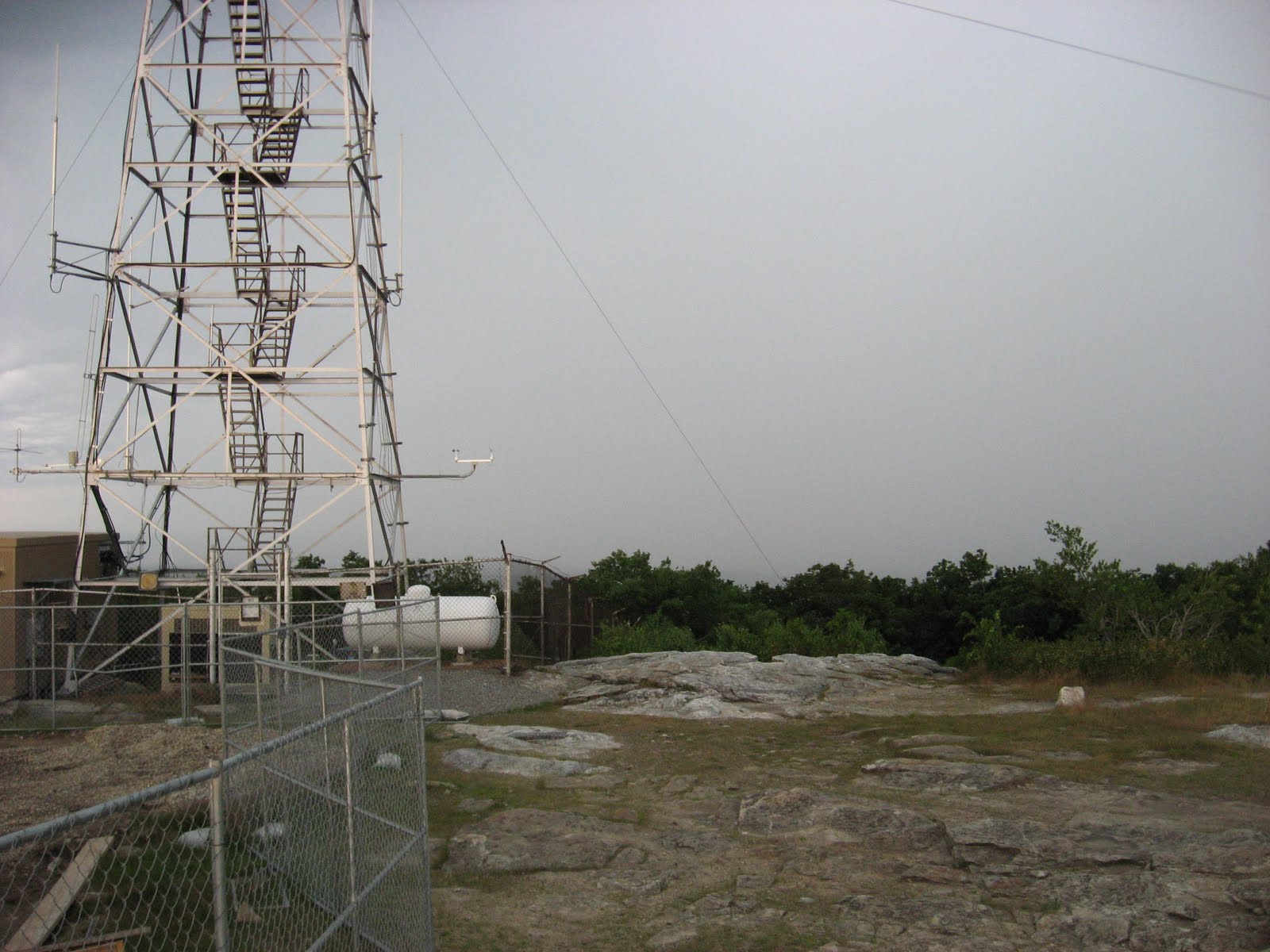
Parker Lodge Antennas - view toward Worcester (S).
 A longer range part of the project will be the relocation of the communications towers that currently sit beside Parker Lodge - adjacent to the Summit Pond.   Eventually, they will come down and the antennas which sit on them will be relocated to a new tower to be located at the far end of the parking lot ... more out of site, although it will be 20 - 25 feet higher due to the need to house all the antennas on one structure.


Radio Relay Towers - view toward Monadnock (N).
As to the towers on the north of the summit, these belong to the federal government and they will not be moving.  Enough said there!
I also learned from the Fire Ranger that the fire watch alert level was very high today and thus they were on duty in the fire tower. 
Fire Tower Manned and Ready to Sound Alerts.
I have previously wondered about the schedule of dismantling the old tower and how it relates to the new tower.  The rangers were just full of information.  
In order to maintain adequate fire watch capability, the project must carefully coordinate the dismantling of one tower and construction and relocation of the fire protection gear to the new one.  In the end, the generators and power supply which currently service the tower and sit within an enclosed area at the base of the tower, will be relocated to "within" the base of the new tower!  Yesterday, I was wondering about what was going into the "basement" area around which the walls are being formed today.  That's the answer ... support equipment for the tower operations.
What about the new observation deck?  The new observation deck will be approximately 10 feet above ground level and will be accessible by a ramp that wraps around the outside of the structure.
Rebar showing the Ramp as it gets higher and higher.

View from opposite direction ... rebar height increasing as the ramp goes higher.
It was a beautiful day, and as Thoreau wrote of the hawk that soared above them while they walked along the "ridge to the north," one could experience the same today.  The hawk still soars over the ridge to the north.  Come visit Wachusett; surely you too will see the hawk and experience the beauty of the mountain.

Hawk Soars Above Wachusett [double click to enlarge - Hawk is right in the center of picture.]

Old Indian Trail on the Ridge to the North


Saturday, July 23, 2011

7/23/11 - Thunder and Lightning

You must love the crust of the earth on which you dwell more than the sweet crust of any bread or cake; you must be able to extract nutriment out of a sand heap.   
Thoreau - January 25, 1858

Thunder and lightning today folks.  Arriving at the summit just in time to take a few quick shots before the rains came!  But, extracting "nutriment out of a sand heap," we did it well and it was a great trip.  So what if you get in the way of the raindrops and come back soaking wet?  


Approach to the site -no rain yet.

View to the East and Boston Skyline
 To the east, the morning view was stunning ... surprisingly great for such a cloudy morning.  One can easily pick out the Boston Skyline at least at this moment in time - a little after 6 in the morning.  The ribbons of distant lands are distinctly marked as one's gaze from The Observatory reaches from the summit to the distant skies beyond the city.  On a foggy morning, the valleys are filled with fog gently lifting from the rivers, ponds, and reservoirs, each giving away its location as well as its name.

But that was soon to disappear....

Foundation Walls Continue
The maze of rebar continues and the forms for the walls progress around the perimeter.

Inside the base walls
Try to imagine what this will look like when complete. If the wall goes around the outside of this "structure," and the four piles for support of the tower are in the center, what becomes of all the space within this building.  Is it part of the tower floor?  The walls must be the inner core about which the viewing ramp will circle until reaching the top of these walls for the viewing platform.  We shall see.

I still wonder about the construction of the "tower."  A friend suggested that the tower proper might well be under construction at another site and it will be either brought to the summit in sections, and a crane will lift it into place, piece by piece, or perhaps it will be airlifted into place by helicopter.  Now that would be quite a feat given the other structures already present and the winds.  No, that might be too much to expect.  But the former idea might well be feasible.  I certainly see no evidence of large structural beams about the site - beams that would enter into the framework of the tower.  Nor is there evidence of and "cabin like cap" from which the forest rangers would work.  There must be more coming.


Inside and ... outside the walls.
About this time, clouds from the west began to rumble, rumble, and rumble. 


Storm Clouds from the SW
 Double Click on this picture (above)... fantastic cloud formation.  It then opened up with buckets of water pouring down on Wachusett, the construction site, and me.

Totally clouded in to the west.


 This was what was coming in on the weather front to replace the somewhat clear skies to the east ... see above picture.

 
The Stone Wall Continues to go up!!!


The Stone Wall at the survey marker is still under construction.  But it is confusing.  What is this structure?  Why so high?  What is going on here?  That wall must be 5' high at this point.  But it is only "one-sided."  Tough to figure out.

But it was time for me to be moving on as the rain had arrived.  A dash down to the parking lots....

Middle of the parking lot ... lower level on the left, upper level on the right.

The spots on the pictures here are rain drops, and it doesn't tell the full story.  It was a downpour and by this point, I was soaking wet!  But you can see the parking lot appears now to be in two levels.  One entrance will have half on the upper section and then one could drive down to the lower section.  It won't be a big drop, but it appears to be multilevel at this time.


Lower level of the parking lot - from Mt. House Trail ... looking West.
Time to move on; the rain was now heavy, with repeated crashes of thunder rolling in from the far side of the mountain.  I was drenched and figured that if I made it below UP SUMIT road, the trees would protect me.  They didn't.


It's not all about construction today.  On the way down, toads, spiders, and birds were about.  And, in the yard of a house just off the mountain, a large family of turkeys out for an early morning stroll.  [these show only a couple chicks of about a dozen or so.]


See you next week! 


Saturday, July 16, 2011

7/16/11 - Mid-July Progress

If you are describing any occurrence... make two or more distinct reports at different times... We discriminate at first only a few features, and we need to reconsider our experience from many points of view and in various moods in order to perceive the whole.  
Thoreau - March 24, 1857


After last weeks foggy start, today was sure to be much improved - and it was.  Bright and sunny today, once again an early morning start.

Actually, the parking lot doesn't look that much different from last week.  There are piles of sand and the hole in the center - for the island, I presume, is still there.


Looking South down Mt. House Trail  - East Side of New Parking Lot


Center of Parking lot - looking south (Power line poles)
As I stood on a giant pile of dirt and gravel, I looked about the parking lot.  It doesn't look much different than last week, I thought.  The backhoe is gone; only one remains at the summit.  I suppose they might need a bulldozer to level the lot before they get to the finishing touches of paving. 

From the Sandpile in the parking lot looking east to the road that will enter.  (Up Summit Road)
What a surprise this morning!  I met an old friend who, like me and like Thoreau, enjoys the early morning air of Wachusett.  That's her on the road heading down with her dog, George. 


Looking northeast up to the summit from the parking lot.


View to the west in the parking lot... this is the back section.

  
Another view to the south - Mt. House Trail on the left.


Progress from last week does not look like much from afar.  But, in fact, great strides are being made.  The  rebar for the observation platform base is now being laid and the forms placed for more cement to be poured.

Something big is going on at the Summit!

Stone Wall being constructed about the U. S. Coastal Marker
 I think this is just great!  The one marker that exists from the 1860's U.S. Coastal Survey team is imbedded into the bedrock right on the summit.  Preserving this historical marker is obviously a priority for the project.  And, obviously, the wall is being built with chunks of bedrock!  This will be interesting to see when it is finished.


From the south side of the summit looking north across the site.

Current Fire Watch Tower peers down at the construction.
The old tower must feel a bit of remorse for she will soon be retired, her life and her work to be replaced by a new guard.

Forms for the observation deck.

From the east looking west.

Foundation with rebar for the walls of the observation platform.

Sand for the cement - lots of it!!

And so once again, I am quite excited by what is taking place on the summit.  At a glance, I first saw the same site as in the last two weeks, but to discover the stone wall about the coastal marker is real special.  We will see what else awaits us as construction continues.


Saturday, July 9, 2011

7/9/11 - Foggy Morning Construction Report


The blueberries which the mountain afforded, added to the milk we had brought, made our frugal supper, while for entertainment, the even-song of the wood-thrush rung along the ridge.  
Thoreau - A Walk to Wachusett

You can be sure the blueberries are still to be found on the summit; after all, it is July!  And so I found the blueberries for an early morning treat along with a summit covered fog.  It is 6:30 am and that will burn off in a couple of hours, making for a glorious day on Wachusett, much like Thoreau experienced in in 1842.

Today I found the foundation complete and workers have begun to hang the forms for the perimeter walls which will be the basis of the observation deck.  Rebar protrudes from the base at approximately 4 - 6" intervals.  Much of the "hole" has now been back-filled and there apparently is need now for but one back-hoe on site. 

Piles and Lower Foundation complete - Rebar will support Upper Foundation.
This wall faces the current fire watch tower on the western side of the summit area.

East side foundation .
I was interested in visiting this morning to learn of the progress of this eastern foundation.  Working quickly, they have now completed it.  The backhoes have also filled in about the wall.  And the "hole" from a few weeks back is almost at ground level again!


Dumpster, Bathroom, Sandbags, and Storage Container. NW side of the site.
Every construction site must have these components ... and I forgot, a picnic table on the southern side of the site for the workers.

Rebar - still more to go.


Sandbag at work securing the fencing.

Heavy AM fog ... from eastern side of summit looking west where pavement from Up Summit ends
One thing is for sure; there will be no more finish lines for road races or the Longsjo Classic here at the end of the pavement on the summit.


Climbing up on the backhoe, I garnered a view from the lower parking towards the east and the lot entrance.


From backhoe looking south to Mt. House Trail and the eastern side of the parking lot.
Probably to secure proper drainage, they have now dug a fairly large (length and width) hole in the middle of the "new" enlarged parking area.  Previously, it had appeared to be all leveled, but today, the hole is there and the lot looks more like a construction site.  This will be the center island of the new lot.

From atop the backhoe, looking to the western end of the parking lot.


From atop the backhoe, looking to the south-western side of the parking lot.


Southern end of the parking lot ... full retainer wall the length of the lot.


Up Summit Road at the Mt. House Trail Crossing


Last year the road improvements portion of the project were completed.  This included improving the surface as well as improved drainage ditches and retainer walls where needed.